Gunbarrel Higway
by Nigel Buxton
LOCATION.
The Gunbarrel Highway links Carnegie Station in central Western Australia with the Meteorological Station at Giles just west of the Northern Territory border. The original highway then extends south east to Victory Downs Station in South Australia. This extension pass through traditional Aboriginal lands and is not open to general traffic.
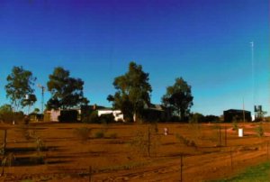 Carnegie Station is accessed from Wiluna, the last township before the
tourist resort at Yulara. This resort provides the support service for the Uluru - Kata
Tjuta National Park. Wiluna is 900 kms North-East of Perth (via Sandstone) or 955kms (via
Meekatharra). Carnegie Station is a further 350 kms east of Wiluna. The road to
Meekatharra is bitumen but the segment to Wiluna is a good graded gravel road. The road
via Sandstone is good gravel from Payne's Find (424kms North of Perth).
Carnegie Station is accessed from Wiluna, the last township before the
tourist resort at Yulara. This resort provides the support service for the Uluru - Kata
Tjuta National Park. Wiluna is 900 kms North-East of Perth (via Sandstone) or 955kms (via
Meekatharra). Carnegie Station is a further 350 kms east of Wiluna. The road to
Meekatharra is bitumen but the segment to Wiluna is a good graded gravel road. The road
via Sandstone is good gravel from Payne's Find (424kms North of Perth).
Fuel is readily available to Meekatharra and in Wiluna. Sandstone is the only source of limited supplies on the alternative route.
HISTORY.
The Gunbarrel Highway was the first of a series of roads surveyed by the late Len Beadell. It was completed in 1958 after 3 years. The roads were cut by a small team of men to provide a way retrieving rocket parts from the Woomera Rocket range. The team worked alone and a full account of their trials and tribulations is written in the book "Too long in the bush" by Len Beadell. This book is a good read and highly recommended.
The road received its name from the tendency for it to travel in straight lines. When you have seen the country involved, you appreciated the bravery and skills of the men concerned.
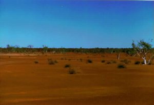
GEOGRAPHY, FLORA & FAUNA.
The track crosses the Great Victoria and Gibson Deserts. You will see claypans, dry rivers, mesa formations and rocks. Although there is vegetation, it is sparse in many areas. Spinifex and low mulga predominate in the dry and it is only after the rain that the desert blooms. Parakeelia (a succulent ground cover) and pigface weed can be seen as well as more attractive flowers including the Sturt Desert pea.
Camels - a left over from early explorers - roam the desert in such numbers that they are sold to Saudi Arabia for racing. Kangaroos can be seen but the majority of mammals are the small nocturnal creatures that rummage around your camp at night. Snakes and other reptiles abound. Kites, eagles, parrots, budgerigars and bustards are representatives of the avian world that frequent the area crossed by the Gunbarrel Highway. The drive is never dull.
WARNING:
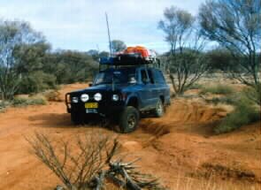
This track covers some very remote areas. It is NOT a journey to be undertaken lightly. It is long and you have to be TOTALLY self-sufficient. It is 4WD only. Allow 600 kms minimum fuel range. Make sure that someone carries a working High Frequency (RFDS) radio. Take 2 spare wheels and the means to repair punctures. Let someone responsible know you are on the highway and when you expect to be in civilisation. If you are late, they can initiate a search. Make sure they know you have completed the crossing.
PREPARATION.
The secret to a successful crossing of the Gunbarrel Highway is adequate preparation. Anticipate 5 nights on the track between Wiluna and Yulara. The journey can be done in less time but you arrive tired rather than invigorated. This trip is your holiday - ENJOY IT.
Fuel is available at Carnegie Station, Warburton, Warakurna roadhouse (by Giles turn off) and Docker River Community. Fuel is more expensive than the city but they have to bring the fuel to the area. (Allow $1-10c/litre). Cash is the preferred currency although Visa and Mastercard may be accepted. Check opening times before you start your journey. Some supplies and spares may be purchased at these fuel outlets, but don't expect a full range. The local communities sell their artworks at Warburton and Warakurna, the standard is good and prices better than the city.
You require transit permits for this road. Details available from Central Land Council [Fax +61 (8) 89529345] in Alice Springs (N.T.)or the Aboriginal Lands Trust in Perth W.A.[Fax +61 (9)235 8088].
Water is not available on this crossing except at the fuel outlets. You must carry enough for your selves and your vehicle. Allow 5 litres/person/day in warm/hot weather and 3litres/person/day in winter. Ensure you have 2 days spare water to allow for breakdowns.
Ensure your vehicle is correctly prepared for the journey. A twin battery system is strongly recommended. Have your vehicle checked over by a good 4WD mechanic with emphasis on suspension, belts and hoses and tyres. Don't start the journey with old, bald tyres. A jack base board is essential, 40cm square and 2 cm thick. It spreads the vehicle's weight and stops the jack sinking in the sand when you change a wheel.
Ideally travel in a convoy.
CONVOY BEADELL STYLE
More information on vehicle preparation is available from the RAC or the local 4WD club. You may also contact the author.
MAPS.
The track is well marked. It is not essential to carry the 1:250,000 scale topographical maps - but they are nice.
The RAC WA produces a good map of the Gunbarrel Highway.
WESTPRINT also produce excellent maps (you need 2, Gunbarrel Highway and Ayers Rock to Alice Springs) of the area. Either are top quality and the choice is yours. They are widely available.
TRACK INFORMATION.
The track is well marked. The surface is of very variable quality, some is good whereas other sections are fairly rough.
 |
Gunbarrel Highway. No truly difficult areas existed last trip (July 1995). There are some quite deep washouts and these vary according to the rains, detours are appearing around the deeper ones. In some areas, the sand is soft and quite deep. Heroes will go through in 2WD but this degrades the track and the NORMAL HUMAN will "TREAD LIGHTLY" |
 |
Mungilli Claypan Take care at Mungilli claypan after the rain or you will sink without trace. Just after the Claypan is a right turn onto the Eagle highway, this takes you to EMPRESS SPRINGS. (see article). |
 A tyre marks the start of the Gary Highway (Everard Junction) which can
take you to the Canning Stock Route.
A tyre marks the start of the Gary Highway (Everard Junction) which can
take you to the Canning Stock Route.
The Geraldton Historical Society has sunk a water bore near the track.
Water is deep and you need a can on a rope to access the water. (Easier to carry your own.)
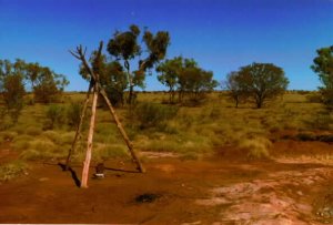
You will see Mount Beadell, named after the surveyor Len Beadell, and where recently a memorial has been erected.

View from Mount Beadell
Beadell plaques can be seen along the track. They are tin plates stuck to trees. Have a read of one!
At one tree, a road to the right takes you down to Warburton. This is the Heather Highway. The straight continuation takes you to Jackie junction and Lake Christopher. At the moment, this segment of the Gunbarrel is closed to traffic. There is an indication from the Traditional owners that, if certain conditions are met, some groups will be able to drive it again. If so, you need enough fuel to go from Carnegie to Warakurna.
This segment is great fun but why tantalise you with the details until you can go there!!
 |
From Warburton to Warakurna , the road is easy EXCEPT
there are some sharp bends to catch the unwary. This usually happens when, because of the
smooth road, you go TOO FAST!! Roll overs on one particular bend just before Warakurna are
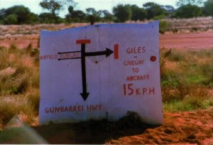
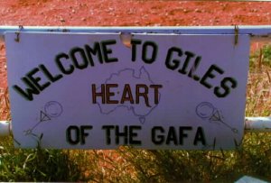
not unusual. Warakurna is a roadhouse close to the turn off to the Meteorological station
at Giles. Tours can be arranged at the Roadhouse. Beware strange traffic. The road is the airstrip. |
 |
Orientation sign. |
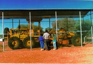 |
The original grader for the Highway is kept at Giles, preserved by the army in "Lenny's Cat Cage". Lenny's Cat Cage. |
 Warakurna to Tjunti (Lasseter's Cave). This is easy driving. Once you cross
the Northern Territory border, camping is only permitted at Tjunti until you reach Yulara.
Warakurna to Tjunti (Lasseter's Cave). This is easy driving. Once you cross
the Northern Territory border, camping is only permitted at Tjunti until you reach Yulara.
Alcohol is NOT permitted on traditional Aboriginal lands. Please respect this and drink water or soft drinks at Tjunti.
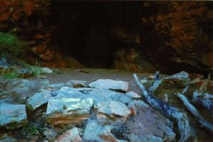
Tjunti - Lasseter's Cave
From Tjunti to Yulara the road is easy. When you enter the Uluru-Kata Tjuta national park, you meet bitumen. From 110kph you have a speed limit of 80kph. The road is as smooth as a baby's bottom after the corrugations and there is a tendency to go a bit quick!
DISTANCES.
| WILUNA to CARNEGIE | 353 |
| CARNEGIE to EVERARD JUNCTION | 286 |
| EVERARD JUNCTION to HEATHER JUNCTION | 120 |
| HEATHER JUNCTION to WARBURTON | 126 |
| WARBURTON to GILES | 230 |
| GILES to DOCKER RIVER | 102 |
| DOCKER RIVER to LASSETER'S CAVE(Tjunti) | 41 |
| LASSETER'S CAVE (Tjunti) to YULARA | 190 |
LAVERTON to WARBURTON ROAD.
Laverton is 320 kms North east of Kalgoorlie (via Leonora). It a straight forward gravel road although remote. It is more heavily travelled than the Gunbarrel Highway. See notes on Empress Springs. Fuel is available at Laverton, Tjurkirla and Warburton. There is a nice camp spot about 80 kms east of Warburton, please keep it that way. Both maps mentioned above cover this road.
COMMENTS.
Both roads are a pleasant drive but approach with respect. Carry out all rubbish and bury faeces at least 40 cm deep. Watch for people in trouble and help them. It could be YOU next. Have a good drink of water regularly (we always have a litre of cold water each roadhouse). Beware of Rental 4WDs on the wrong side of the road. Slow down and pull over to the left for on-coming traffic. It protects both your and their windscreen and lights!
This is a GREAT DRIVE. For more information, please contact the author.
Remember:
"A sky full of stars, a waterhole, and a tree. Life doesn't get
any better than this."


![]()
These pages were last
updated on 3rd November 1998.
Hits since 3rd November 1998: