TALL TIMBER COUNTRY
![]()
TALL TIMBER COUNTRY
by Mark Peacock
Destination: WARREN NATIONAL PARK - Western Australia
It was supposed to have been a straight forward 4WD trip on tracks that I had been over many times before, but we were was soon to find out that all would not go as planned.
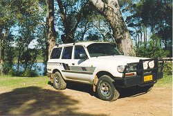
My brother Dave and I, driving my HZJ80 Landcruiser, had planned a relatively easy trip to allow our friend Rob, along with his brother Chris, an introduction to 4WDing after Rob's recent purchase of his GQ Ford Maverick. It was to involve beach driving combined with some reasonably steep fire trails in Jarrah Forrest, along with some demonstrations of vehicle recovery techniques. What we hadn't counted on was the havoc a thunderstorm the previous week would cause !
 The trip started of on a
great note with a forecast of cold but sunny weather, almost too good to be true for this
winter season, especially since the forecast turned out to be right. After an early lunch
at Yeagerup Lake in the Warren National Park it was time to let our tyres down for the
drive in to the beach. The 15 odd kilometre drive in consisted of easy sand trails along
with a crossing of the Yeagerup dunes. Due to the recent rains the trail was reasonably
firm, a far cry from the powdery sand that we had encountered on previous trips during
summer.
The trip started of on a
great note with a forecast of cold but sunny weather, almost too good to be true for this
winter season, especially since the forecast turned out to be right. After an early lunch
at Yeagerup Lake in the Warren National Park it was time to let our tyres down for the
drive in to the beach. The 15 odd kilometre drive in consisted of easy sand trails along
with a crossing of the Yeagerup dunes. Due to the recent rains the trail was reasonably
firm, a far cry from the powdery sand that we had encountered on previous trips during
summer.
It wasn't long before the sound of waves rolling up the beach greeted us as we arrived on the beach front. Even the beach driving itself was no problem due to the damp sand and Rob was starting to wonder what all the fuss was about in making sure he had an experienced 4WDer with him.
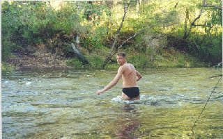
It was only 1km up the beach to the mouth of the Warren River where we were to perform our first river crossing for the trip. The sight that greeted us was one of a fast flowing river about 15 metres wide and of unknown depth, a far cry from the trickle in summer. Chris was quickly volunteered to test the depth due to his natural abilities, he was the tallest at 6'3".
After stripping off his jeans he proceeded to cross at the dune side of the mouth as the river appeared shallower here. The first few steps showed a firm base, but after less than 1/4 way across he sunk halfway to his knees in river silt. No crossing here! Next he tried at the mouth itself, which also had a firm base, but after only 1/3 way across he found himself up to the crown jewels and hastily beating a retreat as some waves started to roll in. We were not going to be able to cross the river here at this time of year.
 Out came the Forestry maps and a ford across the river
was found at Petticoat Lane. It meant backtracking past where we had lunch but with the
river level so high we had little choice. On the drive out we took some time out to
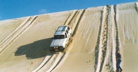
demonstrate to Rob and Chris the way to tackle steep dune descents.
Out came the Forestry maps and a ford across the river
was found at Petticoat Lane. It meant backtracking past where we had lunch but with the
river level so high we had little choice. On the drive out we took some time out to
demonstrate to Rob and Chris the way to tackle steep dune descents.
It was time to pump up our tyres for the dirt tracks and my underbonnet 12v compressor made short work of it. We were soon travelling down a winding road with unbelievable tall Jarrah and Karri trees on each side.
By mid-afternoon we were out of the dunes and had arrived at the river ford where we were again confronted by the swift flowing Warren River. In no time Chris had stripped off and proceeded to test the depth. After a few tentative footsteps he beat a hasty retreat to put some shoes on his feet. The bottom of a river is not quite the same as the white beach sand!
 It only took
a few more steps than before when Chris was past his thighs and the water was getting
deeper. Not only that but the speed of the water meant he was in danger of being washed
away. We decided to give this one a miss to.
It only took
a few more steps than before when Chris was past his thighs and the water was getting
deeper. Not only that but the speed of the water meant he was in danger of being washed
away. We decided to give this one a miss to.
Out came the maps again and we soon picked up another crossing named Heartbreak Road, it sounded ominous. Back in the vehicles and we were off. The trails here would have to be some of the most scenic around, virgin Jarrah and Karri Forrest on rain soaked hills.
Within 20 minutes we were at Heartbreak crossing which turned out to be a 40m wide stretch of the river with what appeared to be a firm base. Chris was quickly put into his now familiar role and had soon walked the crossing. It was thigh deep in places, but was not flowing as fast as before so a mental note was made of the larger boulders. A tarp was placed across the grille of the Landcruiser and I was ready to give it a go.
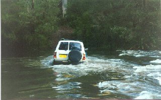 With
my heart in my mouth I proceeded in second low and watched as the bonnet of the cruiser
seemed to disappear. It was a weird sensation to look out the side window and appear to be
almost level with the water. Three quarters of the way across and all was fine. I was now
at the area Chris had felt a few boulders and sure enough I found one too. The dull thud
as my front diff contacted a rock made me wince. A few more revs and it passed underneath,
scrapping various bits of the undercarriage. Luckily it hadn't stopped me. As I clawed my
way up the embankment I let out an almighty yell of delight, what an adrenalin rush.
With
my heart in my mouth I proceeded in second low and watched as the bonnet of the cruiser
seemed to disappear. It was a weird sensation to look out the side window and appear to be
almost level with the water. Three quarters of the way across and all was fine. I was now
at the area Chris had felt a few boulders and sure enough I found one too. The dull thud
as my front diff contacted a rock made me wince. A few more revs and it passed underneath,
scrapping various bits of the undercarriage. Luckily it hadn't stopped me. As I clawed my
way up the embankment I let out an almighty yell of delight, what an adrenalin rush.
It was now Robs turn and we soon realised that both the cameras were in his vehicle and we could not take a front on picture. It was probably just as well as both of our wives would have killed us had they seen exactly what we were doing to "their" cars.
The Maverick was fitted with a snorkel, so the tarp for the grille was dispensed with. It wasn't long before Rob was also successfully across and we were all in high spirits. I asked Rob if he too had experienced an adrenalin rush, which he had. But he hadn't realised his adrenalin was brown!
It was now 4:30pm and we had originally planned to be making camp by this time so we could get some beach fishing in. We estimated that we were only some 15kms from the beach so we would probably make it by 5:00pm.
Within 500m of leaving the river crossing we were confronted with a small tree blocking our path that had only recently blown down. Out with the axe and in no time at all it was quickly dispensed with. We managed only a 100 metres before the next obstacle. This time it was a significantly larger tree blocking our path. Using our chains, we hooked it to the front of the cruiser but managed to move it only a metre before it would go no further. We then hooked Rob's Maverick to the Landcruiser for added power and we were mobile in no time at all.
A roadsign indicated Calcup Rd and we now knew we were on the right track. It was close to dusk now and the chill of the night air had started to move in. The heaters in both vehicles were turned up a notch as we discussed how cold fishing might turn out to be. As luck would have it we would not have to find out!
A large karri tree laying at a 45° angle was blocking our path and it was not going to be a simple matter of just pulling it out of the way. After a quick discussion we decided to build up a ramp so we could simply drive over it. The main branches were soon loped off and placed to provide a ramp.
The first attempt to pass failed as the front locating arm on the cruiser hung up. A bit of reverse power, a quick rearrangement of the branches and over it went. Rob jumped in his Maverick and proceeded to follow. Halfway across the transmission crossmember hung up and neither forward or reverse progress could be made. A quick inspection and the snatch-em strap was called into action. A gentle pull quickly resulted in the Maverick being under its own steam. By the time all the recovery gear was put away headlights were the order of the day(night?). According to the map we still had 10kms to go and it was now highly unlikely any fishing would be done.
The headlights of the cruiser have about as much side-vision as a blinkered horse so the 100W handheld spotlight was removed from the bottom of the toolbox. This meant Dave had to have his window open with the spotlight hanging out, so the heater was put on full. We soon passed some cleared properties on our left, but according to our map they should have been on the right. Either we weren't where we thought we were or the map was wrong!
After following the track beside the fence boundary for some distance, including some steep hills, we were confronted with an endless lake of water that our lights could not penetrate to the other side. The fence line was underwater practically to the top and Chris refused to walk the crossing at night. With spirits starting to deflate and hunger pains starting to arrive we had to turn around. Maybe we had missed a fork in the road.
After backtracking some 2kms we found we had missed the main track and it became apparent why. Calcup Rd originally crossed a major tributary to the river at this point but the bridge was missing. In its place were four long logs, two for each wheel. It may have been possible to attempt the crossing in daylight, but it was now pitch black, freezing cold and some fog had started to move in. On top of that the right hand side "bridge" had been washed away slightly and was about half a metre lower than the other side. Common sense prevailed and we continued to backtrack.
It didn't take a brain surgeon to soon realise that we would have to cross the logs again. This time the crossing was far more difficult as we couldn't get a decent approach angle. Time to call a meeting.
After close inspection the log was found to be cracked in half in the middle of the track. The chains were hooked up to the cruiser and it wasn't long before the two halves separated. The top half was levered to the side of the road but the bottom half was now in a worse position than before. The cruiser couldn't budge it due to a lack of traction, so we hooked a snatch-em strap between the chains and the cruiser. This managed to yank the log for a short distance but traction was still at a premium. The Maverick was then hooked up with a second snatch-em strap and the log was soon mobile. The problem was we were now dragging this god almighty log down the middle of the road and we still couldn't pass by. Luck was finally on our side and the camber of the track finally caused the log to roll to one side. With the temperature still dropping we quickly threw the recovery gear in the vehicles and were on our way.
It was now close to 8:00pm and we were definitely tired, hungry but at least warm, be thankful for small mercies. We came across a signposted cross road and got an exact bearing on the map. A quick decision by Dave and I soon saw us confident we knew where we were. According to our calculations we had to take the next three right hand forks and we would be back on Calcup road but now on the other side of the creek.
Either our map skills needed polishing up or the maps were out of date. The third fork was another shimmering body of water as far as the spotlights could penetrate the fog. A 10 point turn was needed to turn around on the tight track and we were quickly becoming frustrated. A check on the date of the map revealed 12 years of logging tracks and firebreaks had been added since it had been printed. It was now a matter of trial and error to find the right track that would take us back to Calcup road. If only we had a GPS !
After several frustrating deadends we had had enough. It was after 9:00pm and we did not know exactly where we were. We had broken a golden rule by not stopping as night fell when not being on the right track. A quick confirmation over the C.B. and we decided to stop right where we were. We quickly set up camp and had a roaring fire going and were soon enjoying a hot meal.
After a good nights rest and a clear blue sky overhead, our spirits were recharged and it didn't take long before we were off. It's unbelievable what a bit of food and sleep can do, along with some decent light. We could now pick the difference between the major and minor forks and were soon back on Calcup road without a single wrong turn.
It was now a matter of following the trail we had been on several times before. Some sections had been recently bulldozed and the recent rains had caused several large washouts. It turned an easy trail into one that required caution and mindful wheel placement.
Calcup hill was soon reached and it was a picturesque view that greeted us. Almost 2km of glistening white sanddune with a backdrop of rolling waves. The long descent to the waters edge didn't take long and was soon over. We then headed further south along the shore enjoying the firm traction provided by the damp beach sand.
The only remaining obstacle was a river crossing that was normally a trickle but was now flowing quite well. Chris did the honours checking the water depth and when it barely covered his knees we proceeded on. The remaining trip out via private property offered beautiful scenery but little in the way of challenges.
With only the long drive home on the blacktop to go,
the trip was essentially over. Rob had been given a real baptism of fire and was now much
more aware of what the vehicle and his capabilities were. The elements had combined to
give what had planned to have been a relatively easy introduction to 4WDing a test of
skill and perseverance as well as demonstrating how useful a GPS could be. It also
reminded me I needed to sharpen my axe, or bring a chainsaw next time!(c)
4WD Encounter 1998


![]()
These pages were last
updated on 19th November 1998.
Hits since 19th November 1998: