Mundaring to York Track
 This describes how to get from Mundaring,
to the Historic town of York, East of Perth Western Australia. This trip follows a power
line service track through hilly terrain, and several small creek crossings. The track
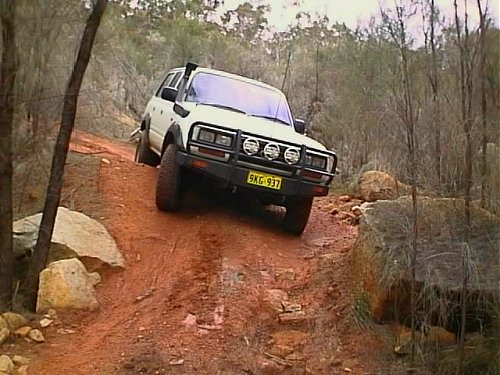
contains very rough sections, consisting of rocky and rutted terrain, with moderate
slopes, tight turns and mud in places. Expect to get "shaken up" on this track.
I recommend that you attempt this track only in vehicles with decent ground clearance, as
you can expect to bottom out on rocks. Run full tyre pressure to minimise the risk of
puncture.
This describes how to get from Mundaring,
to the Historic town of York, East of Perth Western Australia. This trip follows a power
line service track through hilly terrain, and several small creek crossings. The track
contains very rough sections, consisting of rocky and rutted terrain, with moderate
slopes, tight turns and mud in places. Expect to get "shaken up" on this track.
I recommend that you attempt this track only in vehicles with decent ground clearance, as
you can expect to bottom out on rocks. Run full tyre pressure to minimise the risk of
puncture.
| Proceed to Mundaring via heading East along Great Eastern Highway. | |
| 0Km | Start at right hand turn into Nichol Street, in centre of town. Sign says to Mundaring Weir |
| 0.2 | Turn left into Jacoby Street (following signs to Mundaring Weir) |
| 0.4 | Turn right into Maddock Street (again following signs to Mundaring Weir) |
| 0.5 | Turn left Into Phillips Road (still following signs to Mundaring Weir) |
| 3.3 | Pass McCallum Rd on the left, and slow down ready for turn |
| 3.4 | Turn left into small track directly under high tension power lines |
| 3.8 | Go under power lines, and Turn Left at the pipeline |
| 3.9 | Cross over Gravel Rd, following major power lines next to pipeline |
| 5.4 |  Turn
Right at Water tank, over pipeline, and follow major power lines. Track becomes rocky and
proceeds down a hill. Suggest 1st gear. Note: Possible vehicle damage from large rocks! Turn
Right at Water tank, over pipeline, and follow major power lines. Track becomes rocky and
proceeds down a hill. Suggest 1st gear. Note: Possible vehicle damage from large rocks! |
| 7.0 | Crest (top of hill) |
| 7.9 | Cross over Gravel Rd. Track goes up a rocky hill climb, not steep, but long. |
| 8.3 | Crest. Track then proceeds down a steep slope. Use Low ratio, 1st gear to crawl over rocks. |
| 8.9 | Dip (bottom of hill). Cross over a Gravel Rd |
| 9.9 | Crest. |
| 10.3 | Dip. Often contains water (chicken track available!). Track then becomes twisty, as it climbs a medium hill. |
| 10.7 | 1st Crest. Can take either Right track (difficult) or Left track (whoopty do's but Ok) |
| 10.8 | Crest. |
| 11.6 | Cross over Gravel Rd |
| 11.9 | Dip. Often contains water. Track then goes up a rutted hill climb (easy) |
| 12.3 | Crest |
| 13.0 |  Dip. Often contains water Dip. Often contains water |
| 13.7 | Crest |
| 14.1 | Dip, and cross over Gravel Rd |
| 14.5 | Deep ruts in track - Caution! |
| 15.3 | Crest. Warning, I saw many Kangaroos in this area! |
| 16.0 | Track in this area becomes a little better - sandy, 30-40Kph in places. |
| 17.8 | Crest. Track is rocky again. |
| 18.2 | Cross over Gravel Rd. Track becomes clay, and can be slippery in winter. |
| 19.4 | Can take either left or right track. Right track can be tricky. |
| 19.5 | Steep dip. Usually contains water and mud. |
| 20.2 | Crest |
| 20.6 | Down hill climb. Tricky. Use Low ration 1st gear. Right track is steep, rocky, and twisty. |
| 21.0 | 1st dip. Sometimes water |
| 21.1 |  Often water and mud. Can be difficult in winter. Often water and mud. Can be difficult in winter. |
| 21.2 | Deep ditches with water and mud, which can be in-passable. Chicken tracks available! Clay surface. |
| 21.5 | Tricky, windy, rocky section of track. |
| 21.6 | Small dip, sometimes water |
| 23.1 | Crest. Down easy hill climb, take Left track. Difficult mid section |
| 23.5 | Small dip, often with water in it. |
| 23.6 | Dip. Often water. Track then goes up a hill, which is quite rutted. |
| 24.2 | Crest |
| 25.3 | Dip. Often has water. |
| 25.6 | Rocky hill climb |
| 25.8 | Gravel clearing on right has good views over valley. Nice photo spot! |
| 25.9 | Crest |
| 26.7 | Crest |
| 27.1 | Pass track on right, and cleared farmland on left, continue ahead. |
| 28.5 | Often water, which can be deep and muddy in winter. |
| 29.2 | Dip, which in winter is quite a challenge. Wide water area for the next 200m. Very muddy. |
| 29.7 | Cross over Gravel Rd (I think it is Nganguring Rd) |
| 30.0 | Track bends 90 degrees to the left |
| 31.2 | Main bitumen highway. Turn right towards York (select 2WD) |
| 42.4 | Turn right into Mount Observation, (Catchment Rd). This are contains picnic spots with BBQs. At this point I reset my trip meter, to allow for those who drove around the Mt Observation area for lunch, or for those who want to just do the easy second stage of this trip! |
| 0Km | Mount Observation entrance (as above), which is the start of Catchment road. This is an easy single lane Gravel track, which you can maintain up to 40Kph on comfortably. Follow the main track, never branching off to either side on any of the smaller tracks. |
| 5.6 | Hump - slow down unless you want to become airborne! |
| 5.9 | Pass track on the right (Pony Rd). Continue ahead |
| 6.8 | Turn Left, which is still Catchment Rd |
| 8.9 | Track becomes quite windy as it weaves through trees. Watch out for Emus in this area! |
| 9.7 | Pass bee hives on the left |
| 11.9 | Turn Left onto main Gravel Rd, Helena Rd. This leads back to Main Bitumen highway. |
| ? | Once hitting the highway, turn right and proceed to York. The distance to York from this point is about 20Km. There are dozens of tracks heading towards York, but as I have not completed my survey of the area, I can't publish the directions. Continuing along Catchment road ends up heading South then East, only to do a complete loop, and join up with one of the many cross roads passed earlier in the trip! Stay tuned for more info! (c) 1998 4WD Encounter |


![]()
These pages were last
updated on 11th November 1998.
Hits since 11th November 1998: